HoudahGeo Overview
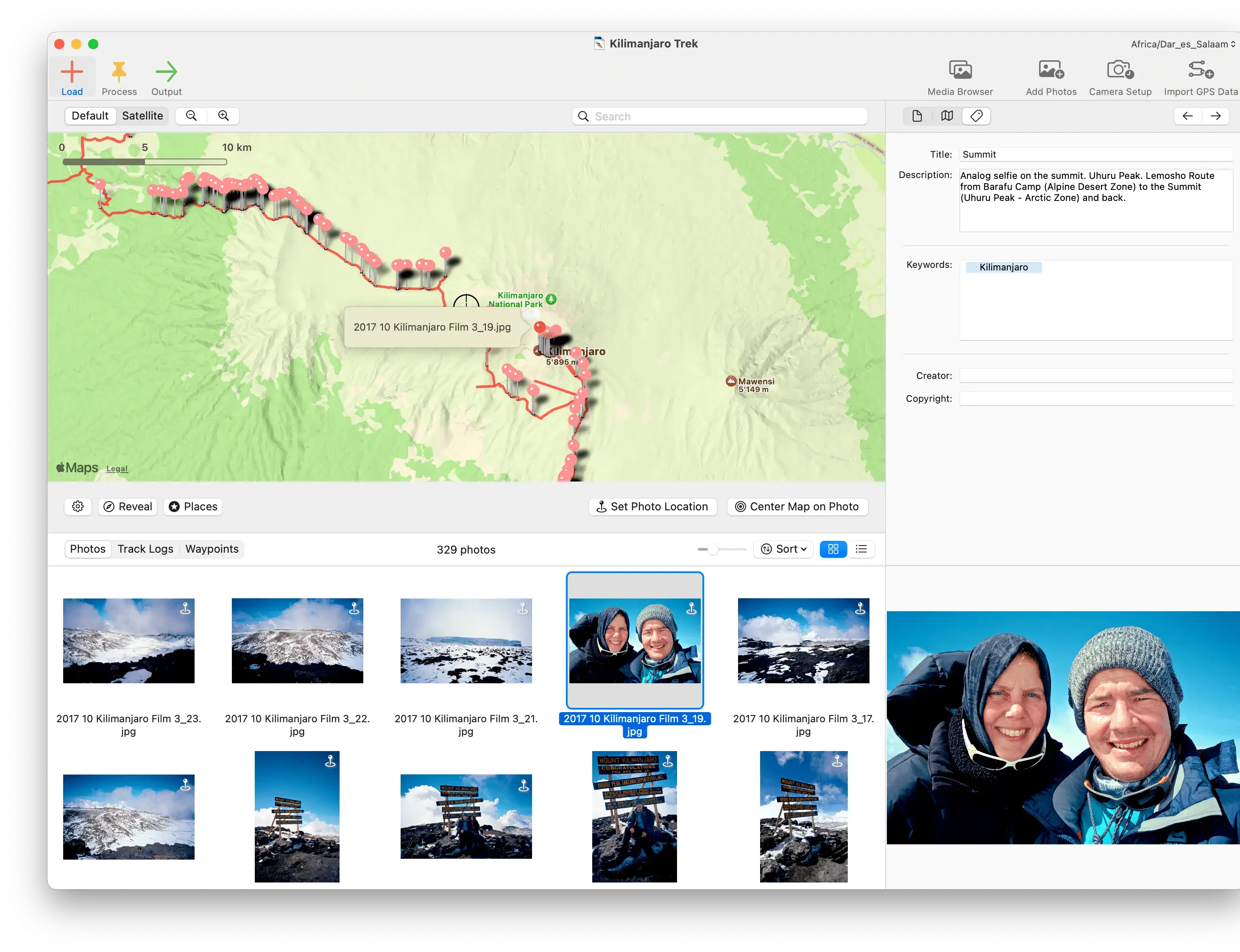
HoudahGeo for Mac is a photo and video geotagging app by Houdah Software that embeds GPS coordinates directly into your media files, the same way a GPS-enabled camera would. It organizes the process into three steps: Load, Process, and Output, so you add your files and track logs, verify or adjust locations, then write the final data back to your files. Version 7 added video geotagging, a redesigned interface, and a new Camera Setup tool for correcting timestamps. It works with GPX, NMEA, Garmin FIT, and Wintec TES track logs, or you can geocode manually using reference photos or a built-in world map. HoudahGeo syncs directly with Apple Photos and also works alongside Adobe Lightroom.
Why Choose HoudahGeo for Mac
Apple Photos can assign rough locations to your library, but that data doesn't get written into the files themselves. HoudahGeo embeds GPS coordinates, altitude, and location names directly into EXIF, XMP, and IPTC metadata, so the information stays with your photos and videos no matter where you move them later.
It's particularly useful if you shoot with your camera's GPS turned off, which many photographers do to save battery on long trips. You can match photos to a GPX track log recorded separately, or use geotagged reference photos from your phone to fill in the gaps. One real limitation worth knowing: some users find the per-license upgrade policy confusing, since major version upgrades can require an additional fee even within a year of purchase, so it's worth checking current upgrade terms before buying if you plan to update later.
Key Features
- Automatic geocoding using GPX, NMEA, Garmin FIT, or Wintec TES track logs
- Video geotagging for drone footage, action cams, and other clips
- Reference photo geocoding for cameras without built-in GPS
- Interactive map for manually verifying or assigning locations
- Camera Setup tool for correcting photo date and time before geocoding
- Reverse geocoding that fills in city, province, and country names
- Support for JPEG, RAW, JPEG+RAW pairs, and XMP sidecar files
- Weather and dive log data fields for extra context
- KML and KMZ export for viewing routes in Google Earth or Google My Maps
- Direct sync with Apple Photos and compatibility with Adobe Lightroom
What's New in 7.2.1 Version
Recent HoudahGeo updates focus on stability fixes following the version 7 redesign. Recent changes include:
- Fixed a crash during "Save As" on macOS Tahoe
- Fixed a crash affecting Google Earth export
- Continued refinements to the version 7 interface and map experience
- The larger version 7 update itself introduced video geotagging, a new Camera Setup tool, a redesigned media browser, and faster Apple Photos integration, marking one of the bigger overhauls in the app's history.
Supported macOS Versions
HoudahGeo works with macOS 12.4 (Monterey) through macOS 26 (Tahoe) and runs natively on Apple Silicon Macs. Since it writes metadata directly into image and video files, keeping backups of your originals before a large batch geotagging session is good practice, regardless of macOS version.
How to Install HoudahGeo on macOS?
Setting up HoudahGeo on your Mac takes just a few steps.
- Download the latest version of HoudahGeo for Mac.
- Open the downloaded disk image (.dmg) file.
- Drag the HoudahGeo icon into your Applications folder.
- Launch HoudahGeo from your Applications folder.
- Grant any permissions macOS requests for accessing your Photos library.
- Once installed, you can start a new project and begin loading photos or videos right away.
How to Use HoudahGeo Mac?
- Open HoudahGeo and start with the Load step, adding your photos, videos, and any GPS track logs.
- Let HoudahGeo automatically match locations by timestamp where possible.
- Move to the Process step to verify locations or manually adjust any that need correction.
- Use the Camera Setup tool first if your camera's clock needs correcting.
- In the Output step, write the location data to your files and sync with Apple Photos.
- Export a KML or KMZ file if you want to view your route in Google Earth.
Final Verdict
HoudahGeo fills a specific, genuine need: getting real GPS data embedded directly into your photo and video files, not just tagged loosely inside Apple Photos. Its track log support, reference photo matching, and now video geotagging cover most real-world geocoding scenarios, including remote trips where GPS-enabled cameras fall short. The price and upgrade policy draw some fair criticism, but for photographers, researchers, or professionals who need permanent, file-embedded location data, HoudahGeo remains one of the most capable tools available on Mac.
Download HoudahGeo for Mac Latest Version
Ready to add real GPS data to your photo and video library?
Download HoudahGeo for Mac to geotag your photos and videos using track logs, reference photos, or an interactive map, with results written directly into your files. Whether you're documenting a wilderness trip, tagging drone footage, or organizing a real estate shoot by location, HoudahGeo gives your media permanent, portable location data that stays with the file wherever it goes.